
Asia Pacific Geographic Information System Software (GIS) for Agriculture Market Research Report: Forecast (2022-2027)
By Solution Type (Cloud, On-Premise), By Application (Crop Monitoring, Soil Analysis, Irrigation Monitoring, Others), By Country (China, Japan, India, Vietnam, Thailand, Indonesia, ... Australia & New Zealand, Rest of Asia Pacific), By Company ((Hexagon AB Cisco, Topcon Corpration, Oracle Corporation, Ceinsys TECH Ltd, Environmental System Research Institute, Satpalda Geospatial Services, GeoMarvel, SuperMap Software Co., Ltd, Spatial Vision, AgriNet Solutions, Hi-Target Surveying Instrument Co., Ltd, SuperMap Software Co., Ltd, Takor Group, Trimble) Read more
- Environment
- Mar 2022
- Pages 165
- Report Format: PDF, Excel, PPT
Market Definition:
GIS software in agriculture is used for precision farming and helps farmers increase crop productivity. It includes geomatics technology that enables farmers to map & forecast the present & future conditions of precipitation, weather conditions, including temperature & rainfall, crop outputs, etc. Additionally, Agriculture GIS software can analyze soil data & determine which crop would have been planted at which place and how to maintain soil nutrition.
With the gradual modernization of agriculture in countries like China, Japan, India, Australia, etc., the utilization of Geographic Information System (GIS) Software is growing manifold. Asia-Pacific can rightly be called the food basket of the world. Across the region, countries like China & India have more than 20% of the global cropland as of 2022. In addition, both countries hold the top two positions in the production of horticultural & agricultural crops. Hence, the modernization of agriculture in both countries becomes quite imperative to continue feeding humanity.
Market Insights:
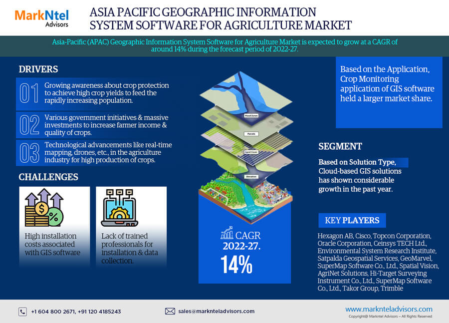
The Asia-Pacific Geographic Information System (GIS) Software for Agriculture Market is expected to grow at a CAGR of around 14% during the forecast period, i.e., 2022-27. The growth of the market is driven primarily by the increasing awareness about crop protection to achieve high crop yields owing to the rapidly increasing population. Moreover, various government initiatives & massive investments across the region to increase farmer income & quality of crops are other crucial factors driving the demand for GIS software in the agriculture sector. For instance:
| Report Coverage | Details |
|---|---|
| Study Period | Historical Data: 2017-20 |
| Base Year: 2021 | |
| Forecast Period: 2022-27 | |
| CAGR (2022-2027) | 14% |
| Country Covered | China, Japan, India, Vietnam, Thailand, Indonesia, Australia & New Zealand, Rest of Asia Pacific |
| Key Companies Profiled | Hexagon AB, Cisco, Topcon Corpration, Oracle Corporation, Ceinsys TECH Ltd, Environmental System Research Institute, Satpalda Geospatial Services, GeoMarvel, SuperMap Software Co., Ltd, Spatial Vision, AgriNet Solutions, Hi-Target Surveying Instrument Co., Ltd, SuperMap Software Co., Ltd, Takor Group Trimble |
| Unit Denominations | USD Million/Billion |
- In 2021, the Ministry of Agriculture India signed a Memorandum of Understanding (MoU) with Cisco to integrate GIS technology, drones, & robots into the agriculture industry for high crop production.
Moreover, technological advancements like real-time mapping, drones, etc., in the agriculture industry for high production of crops are continuously fueling the overall market growth across Asia-Pacific. GIS software provides information regarding crop development to farmers at the growing stage & enables them to implement timely intervention & ensure high crop production. It also includes information related to water availability, high temperature, nutrient deficiency, excessive chemicals, etc. Therefore, the demand for GIS technology in the agricultural sector has shown considerable growth in the past few years.
- In 2017, the Vietnam Agriculture Ministry partnered with the Swiss Agency for Development and Co-operation to develop crop monitoring technology for rice production and forecast productivity with around 90% accuracy.
Impact of Covid-19 on the Asia-Pacific Geographic Information System (GIS) Software for Agriculture Market
The Covid-19 pandemic in 2020 had a decelerating effect on most industries across Asia-Pacific. However, the Asia-Pacific Geographic Information System (GIS) Software for Agriculture Market observed a dual impact. Initially, the market faced certain challenges like the hampered supply chain & shutdown of manufacturing industries that affected several sectors like aviation, aerospace, automotive, information technology, etc., which, in turn, resulted in reduced demand for GIS software.
The manufacturing & sales of new products came to a halt across the region since the pandemic disrupted the entire ecosystem across Asia-Pacific. Hence, the production suspension amidst the crisis and reduced demand had an unprecedented impact on GIS software sales. Meanwhile, during the pandemic, the utilization of GIS software by farmers & agriculturalists increased, but the sales of products showed stagnant growth.
Moreover, seeing a gradual improvement in the pandemic situation, governments across the region have uplifted the restrictions since 2021 and allowed the recommencement of all research operations. Currently, the market is on the track of regaining its usual pace & expects a boom in the years to come.
Market Segmentation
Based on the Solution Type:
- Cloud
- On-Premise
Of both, the demand for Cloud-based GIS solutions has shown considerable growth in the past year, owing to increasing demand for real-time geospatial data. It allows farmers to capture land in real-time remotely from any place. It also aids in sharing information related to weather, soil conditions, fertilizer usage, and warning for a natural disaster. These are the crucial aspects based on which the demand for GIS software has rapidly increased in the historical period, and the same trend is likely to be followed in the coming years. For instance:
- In 2021, the Government of India and farmer welfare signed MOU with Microsoft to develop a cloud-based Unified Farmer Services Interface for creating digital agricultural ecosystems. This platform provides end-to-end services across the agriculture food value chain to farmers.
Based on By Application:
- Crop Monitoring
- Soil Analysis
- Irrigation Monitoring
- Others
Here, the Crop Monitoring application of GIS software held a larger market share than other applications during the historical period, owing to the increasing demand for crop stress information among farmers. It enables farmers to take actions based on information collated through the GIS software about the progress of crops and, in turn, avoid unnecessary risks of extra expenditure. GIS-based crop monitoring provides a data-driven approach by integrating sensors, gateway connectivity, & a dashboard to monitor crops in real-time.
It records all the important statistics with respect to the presence of appropriate amount of water, temperature, chemicals, etc. Moreover, the Crop Monitoring application also triggers actions to mitigate the impact of biotic & abiotic stress on crops. By observing these benefits, the governments of various countries in Asia-Pacific have started providing crop monitor solutions to farmers. For instance:
- In 2019, the Government of India signed a MoU with ITC to provide personalized site-specific crop advisory services to farmers using a digital crop monitoring platform.
Country Landscape
Geographically, Asia-Pacific Geographic Information System (GIS) Software for Agriculture Market expands across:
- India
- China
- Indonesia
- Thailand
- Australia
- Rest of Asia-Pacific
Of all countries in Asia-Pacific, India has captured a substantial market share in recent years, owing primarily to the mounting awareness about crop protection and the growing demand for solutions for unpredictable climatic conditions. According to India Brand Equity Foundation, in 2019, India was the second-largest producer of wheat, rice, sugarcane, cotton, etc. Additionally, the immense government support to farmers in order to increase crop productivity & their income by deploying precision technologies, including farm automation, sensing & monitoring solutions, etc., are other crucial factors that augmented the market growth across India during the historical period. For instance:
- In 2021, the Government of India launched 35 crop varieties with special traits, such as climate resilience and higher nutrient contents.
Market Dynamics:
Key Drivers: Adoption of Advanced Technologies to Increase Crop Production
The adoption of drones, light spectrum, etc., in the agriculture industry to boost crop production has significantly boosted the Asia-Pacific Geographic Information System (GIS) Software for Agriculture Market in the previous few years. The GIS software helps farmers monitor the condition of crops and predict the wind direction, soil types, rainfall amount required to assist crop management, etc. Hence, the rising integration of advanced technologies into conventional agricultural procedures, i.e., enabling enhanced crop production, would boost the Asia-Pacific Geographic Information System (GIS) Software for Agriculture Market in the coming years.
- In 2017, Ceinsys Tech Ltd conducted soil mapping in India covering an area of approximately 13000 sq. km to find the information related to nutrients & sub-nutrients, including pH content, nitrogen, soil moisture, etc.
- The same year, Sinochem launched Modern Agriculture Platform (MAP) with a crop monitoring app to offer a wide range of services to farmers & help them increase crop productivity.
Growth Challenge: Higher Installation Costs
The integration & implementation of multiple hardware and involvement of advanced technologies make the GIS software costly. Additionally, it requires trained professionals for its installation & data collection, which is another aspect that increases the overall cost of GIS software for farmers.
The region includes some primary agriculture-based economies of the world, such as India, China, Indonesia, Vietnam, etc., where numerous farmers can extract profits to sustain their expenditure. Thus, adopting such high-cost technologies is difficult for them and impacts the total revenue of the Geographic Information System (GIS) Software for Agriculture Market across Asia-Pacific.
Key Trend in the Market
- Rapid Adoption of Drones in Precision Agriculture
The increasing demand for precision agriculture across Asia-Pacific has significantly boosted the demand for drones for crop monitoring and collecting the Agri data using cloud technology. This data is used with GIS software to forecast the weather conditions, crop growth status, & the presence of nutrients in the soil.
- In 2019, approximately 4500 drones were used in China to provide crop monitoring solutions and spray pesticides for cotton productivity.
Hence, with the adoption of drones in agriculture farming becoming one of the rapidly emerging trends, the demand for GIS software is expected to increase in the forecast period.
Key Questions Answered in the Market Research Report:
- What are the overall statistics or estimates (Overview, Size- By Value, Forecast Numbers, Segmentation, Shares) of the Asia-Pacific Geographic Information System (GIS) Software for Agriculture Market?
- What are the country-wise industry size, growth drivers, and challenges?
- What are the key innovations, opportunities, current & future trends, and regulations in the Asia-Pacific Geographic Information System (GIS) Software for Agriculture Market?
- Who are the key competitors, their key strengths & weaknesses, and how do they perform in the Asia-Pacific Geographic Information System (GIS) Software for Agriculture Market based on the competitive benchmarking matrix?
- What are key results derived from surveys conducted during the Asia-Pacific Geographic Information System (GIS) Software for Agriculture Market study?
Frequently Asked Questions
- Introduction
- Product Definition
- Research Process
- Market Segmentation
- Assumptions
- Executive Summary
- Impact of COVID-19 on Asia-Pacific Geographic Information System (GIS) Software for Agriculture Market
- Asia Pacific Agriculture Industry Outlook, 2015-2021
- Asia-Pacific Geographic Information System (GIS) Software for Agriculture Market Pricing Analysis
- Asia-Pacific Geographic Information System (GIS) Software for Agriculture Market Trends & Insights
- Asia-Pacific Geographic Information System (GIS) Software for Agriculture Market Dynamics
- Impact Analysis
- Drivers
- Challenges
- Asia-Pacific Geographic Information System (GIS) Software for Agriculture Market Hotspots & Opportunities
- Asia-Pacific Geographic Information System (GIS) Software for Agriculture Market Porter’s Five Forces Analysis
- Asia-Pacific Geographic Information System (GIS) Software for Agriculture Market Outlook, 2017-2027F
- Market Size & Analysis
- By Revenues (USD Million)
- Market Share & Analysis
- By Solution Type
- Cloud
- On-Premise
- By Application
- Crop Monitoring
- Soil Analysis
- Irrigation Monitoring
- Others
- By Country
- China
- Japan
- India
- Vietnam
- Thailand
- Indonesia
- Australia & New Zealand
- Rest of Asia Pacific
- By Company
- Revenue Shares
- Competition Characteristics
- By Solution Type
- China Geographic Information System (GIS) Software for Agriculture Market Outlook, 2017-2027F
- Market Size & Analysis
- By Revenues (USD Million)
- Market Share & Analysis
- By Solution Type
- By Application
- Market Size & Analysis
- Japan Geographic Information System (GIS) Software for Agriculture Market Outlook, 2017-2027F
- Market Size & Analysis
- By Revenues (USD Million)
- Market Share & Analysis
- By Solution Type
- By Application
- Market Size & Analysis
- India Geographic Information System (GIS) Software for Agriculture Market Outlook, 2017-2027F
- Market Size & Analysis
- By Revenues (USD Million)
- Market Share & Analysis
- By Solution Type
- By Application
- Market Size & Analysis
- Vietnam Geographic Information System (GIS) Software for Agriculture Market Outlook, 2017-2027F
- Market Size & Analysis
- By Revenues (USD Million)
- Market Share & Analysis
- By Solution Type
- By Application
- Market Size & Analysis
- Thailand Geographic Information System (GIS) Software for Agriculture Market Outlook, 2017-2027F
- Market Size & Analysis
- By Revenues (USD Million)
- Market Share & Analysis
- By Solution Type
- By Application
- Market Size & Analysis
- Indonesia Geographic Information System (GIS) Software for Agriculture Market Outlook, 2017-2027F
- Market Size & Analysis
- By Revenues (USD Million)
- Market Share & Analysis
- By Solution Type
- By Application
- Market Size & Analysis
- Australia & New Zealand Geographic Information System (GIS) Software for Agriculture Market Outlook, 2017-2027F
- Market Size & Analysis
- By Revenues (USD Million)
- Market Share & Analysis
- By Solution Type
- By Application
- Market Size & Analysis
- Market Size & Analysis
- Asia-Pacific Geographic Information System (GIS) Software for Agriculture Market Key Strategic Imperatives for Growth & Success
- Competition Outlook
- Competition Matrix
- Brand Specialization
- Target Markets
- Target End Users
- Research & Development
- Strategic Alliances
- Strategic Initiatives
- Company Profiles
- Hexagon AB
- Cisco
- Topcon Corpration
- Oracle Corporation
- Ceinsys TECH Ltd
- Environmental System Research Institute
- Satpalda Geospatial Services
- GeoMarvel
- SuperMap Software Co., Ltd
- Spatial Vision
- AgriNet Solutions
- Hi-Target Surveying Instrument Co., Ltd
- SuperMap Software Co., Ltd
- Takor Group
- Trimble
- Competition Matrix
- Disclaimer
MarkNtel Advisors follows a robust and iterative research methodology designed to ensure maximum accuracy and minimize deviation in market estimates and forecasts. Our approach combines both bottom-up and top-down techniques to effectively segment and quantify various aspects of the market. A consistent feature across all our research reports is data triangulation, which examines the market from three distinct perspectives to validate findings. Key components of our research process include:
1. Scope & Research Design At the outset, MarkNtel Advisors define the research objectives and formulate pertinent questions. This phase involves determining the type of research—qualitative or quantitative—and designing a methodology that outlines data collection methods, target demographics, and analytical tools. They also establish timelines and budgets to ensure the research aligns with client goals.
2. Sample Selection and Data Collection In this stage, the firm identifies the target audience and determines the appropriate sample size to ensure representativeness. They employ various sampling methods, such as random or stratified sampling, based on the research objectives. Data collection is carried out using tools like surveys, interviews, and observations, ensuring the gathered data is reliable and relevant.
3. Data Analysis and Validation Once data is collected, MarkNtel Advisors undertake a rigorous analysis process. This includes cleaning the data to remove inconsistencies, employing statistical software for quantitative analysis, and thematic analysis for qualitative data. Validation steps are taken to ensure the accuracy and reliability of the findings, minimizing biases and errors.
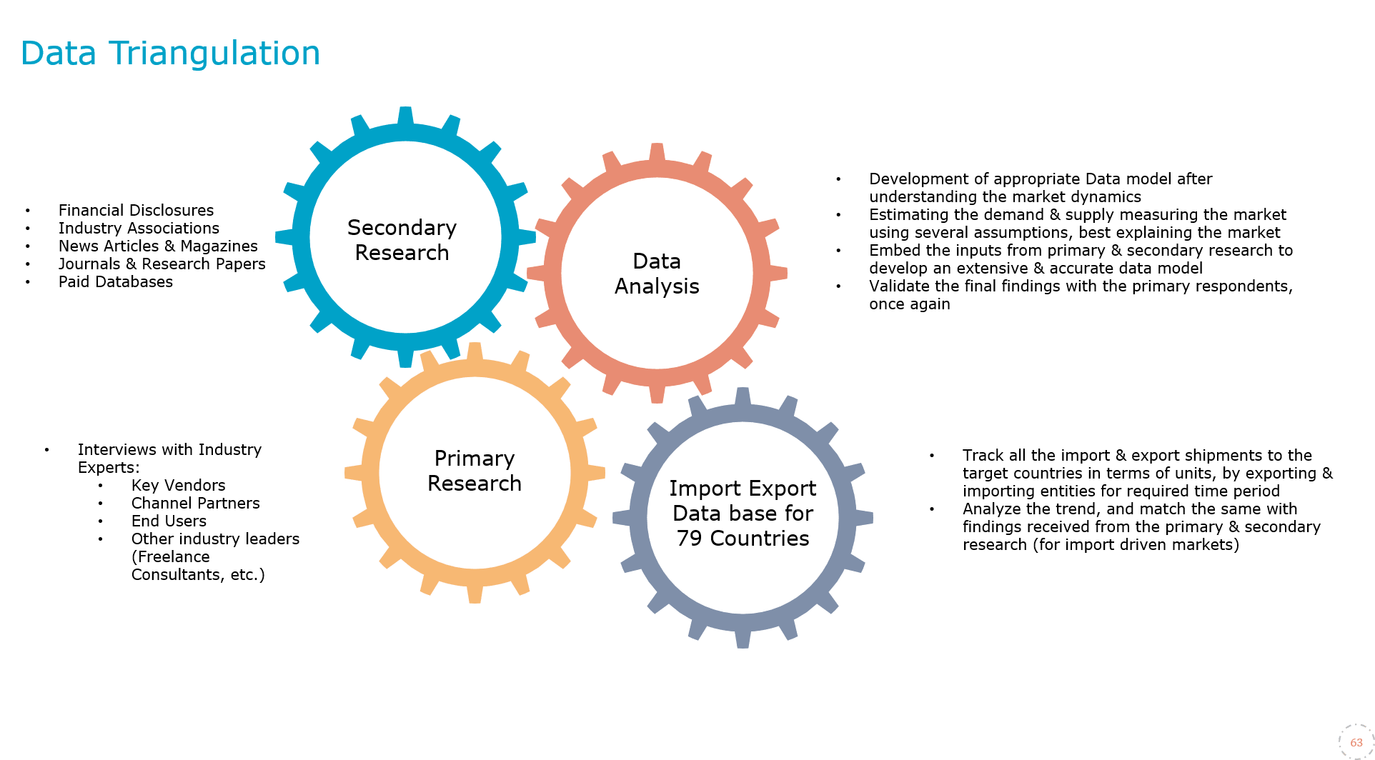
4. Data Forecast and FinalizationThe final phase involves forecasting future market trends based on the analyzed data. MarkNtel Advisors utilize predictive modeling and time series analysis to anticipate market behaviors. The insights are then compiled into comprehensive reports, featuring visual aids like charts and graphs, and include strategic recommendations to inform client decision-making
We offer flexible licensing options to cater to varying organizational needs. Choose the pricing pack that best suits your requirements:
Buy Now