

Brazil Satellite Earth Observation Systems Market Research Report: Trends, Forecast & Opportunities (2026-2032)
By Type (Earth Observation Data, Value Added Services), By Satellite System (Optical Observation Satellites, Radar / Synthetic Aperture Radar (SAR) Satellites, Multispectral Satell ... ites, Hyperspectral Satellites, Small Satellites / Nanosatellites / CubeSats), By Orbit Type (Low Earth Orbit (LEO), Medium Earth Orbit (MEO), Geostationary Orbit (GEO)), By Application (Agriculture Monitoring & Precision Farming, Environmental Monitoring, Urban & Regional Planning, Disaster Management & Risk Assessment, Infrastructure Monitoring, Energy & Resources Monitoring, Climate Services & Meteorology, Defense, Security & Border Surveillance), By End-User (Government Agencies, Urban Development and Cultural Heritage, Agriculture, Climate Services, Energy and Raw Materials, Infrastructure, Others), and others Read more
- Aerospace & Defense
- Feb 2026
- Pages 140
- Report Format: PDF, Excel, PPT
Brazil Satellite Earth Observation Systems Market
Projected 6.8% CAGR from 2026 to 2032
Study Period
2026-2032
Market Size (2025)
USD 80 Million
Market Size (2032)
USD 126.5 Million
Base Year
2025
Projected CAGR
6.8%
Leading Segments
By Type: Earth Observation Data
Brazil Satellite Earth Observation Systems Market Report Key Takeaways:
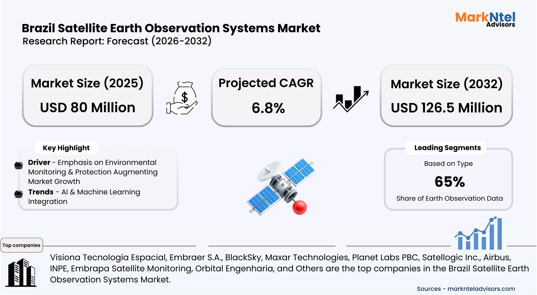
- Market size is valued at around USD 80 million in 2025 and is projected to reach USD 126.5 million by 2032. The estimated CAGR from 2026 to 2032 is around 6.8%, indicating strong growth.
- The Southeast region holds the largest market share of about 40% in the Brazil Satellite Earth Observation Systems Market in 2025.
- By type, the earth observation data segment seized a significant share of about 65% in the Brazil Satellite Earth Observation Systems Market in 2025.
- By orbit type, the low-earth orbit (LEO) segment captured a significant share of about 62% in the Brazil Satellite Earth Observation Systems Market in 2025.
- Leading satellite earth observation systems companies in the Brazilian market are Visiona Tecnologia Espacial, Embraer S.A., BlackSky, Maxar Technologies, Planet Labs PBC, Satellogic Inc., Airbus, INPE, Embrapa Satellite Monitoring, Orbital Engenharia, and Others.
Market Insights & Analysis: Brazil Satellite Earth Observation Systems Market (2026-32):
The Brazil Satellite Earth Observation Systems Market size was valued at around USD 80 million in 2025 and is projected to reach USD 126.5 million by 2032. Along with this, the market is estimated to grow at a CAGR of around 6.8% during the forecast period, i.e., 2026-32.
The Brazil Satellite Earth Observation Systems Market has experienced steady growth as the country expands its national space and remote sensing infrastructure. Brazil’s Amazonia mission, featuring satellites such as Amazônia‑1, provides high-resolution imagery for deforestation, agriculture, and water resource monitoring, enabling government agencies to enforce environmental regulations effectively. Programs like DETER deliver near-real-time alerts on illegal deforestation, supporting IBAMA and state authorities in timely response actions, contributing to an 11.08% decline in Amazon deforestation from August 2024 to July 2025 .
Satellite EO data serves multiple end users, including environmental agencies, research institutions, and defense organizations. For example, Initiatives like the MapBiomas project apply machine learning to Landsat imagery for annual land-use maps, supporting climate policy and land management. Brazilian NewSpace firms, such as PION Labs, are contributing with nanosatellites like PION-BR2 for telecommunication experiments, while international collaborations with China expand joint EO and satellite-based internet initiatives .
The market is further driven by technological trends, including AI and ML integration, which enhance real-time environmental monitoring, land-use classification, and predictive analytics. These advancements increase data accuracy and accelerate decision-making, making satellite EO applications more valuable across governmental and institutional users.
Furthermore, Brazil is investing in future satellite missions, such as Amazonia‑1B, scheduled for 2027, which will provide higher-resolution imagery, expanded coverage, and enhanced monitoring of environmental, agricultural, and coastal resources . Combined with international collaborations, AI adoption, and growing institutional applications, the market is poised for sustained growth through 2032, driven by strategic, environmental, and technological factors.
Brazil Satellite Earth Observation Systems Market Recent Developments:
- 2025: Brazil formalized a decree establishing joint development of the CBERS‑6 Earth observation satellite with China. It will feature an X‑band SAR sensor for all‑weather, day/night monitoring, boosting environmental and security data capabilities; launch is planned for 2028 .
- 2025: Satellogic Inc. and Telespazio Brasil signed a multi‑year agreement with the Brazilian Air Force to deliver low‑latency high‑resolution satellite imagery from the NewSat constellation, enhancing real‑time territorial monitoring for defense.
Brazil Satellite Earth Observation Systems Market Scope:
| Category | Segments |
|---|---|
| By Type | (Earth Observation Data, Value Added Services), |
| By Satellite System | (Optical Observation Satellites, Radar / Synthetic Aperture Radar (SAR) Satellites, Multispectral Satellites, Hyperspectral Satellites, Small Satellites / Nanosatellites / CubeSats), |
| By Orbit Type | (Low Earth Orbit (LEO), Medium Earth Orbit (MEO), Geostationary Orbit (GEO)), |
| By Application | (Agriculture Monitoring & Precision Farming, Environmental Monitoring, Urban & Regional Planning, Disaster Management & Risk Assessment, Infrastructure Monitoring, Energy & Resources Monitoring, Climate Services & Meteorology, Defense, Security & Border Surveillance), |
| By End-User | (Government Agencies, Urban Development and Cultural Heritage, Agriculture, Climate Services, Energy and Raw Materials, Infrastructure, Others), |
Brazil Satellite Earth Observation Systems Market Driver:
Emphasis on Environmental Monitoring & Protection Augmenting Market Growth
Environmental monitoring and protection are critical drivers of the Brazil Satellite Earth Observation Systems Market, as Brazil relies on satellite data to safeguard its vast ecosystems. For example, the Floresta+ Amazon Project, launched in 2025 by the UN Development Programme (UNDP) in collaboration with Brazil’s Ministry of Environment and Climate Change (MMA). Under this initiative, over USD 280,000 was allocated as direct compensation to 200 farming families across 15 municipalities in Amazonas, recognizing their efforts to preserve approximately 14,000 hectares of native forest and maintain 8 million living trees .
Satellite Earth observation systems play a pivotal role in such programs by providing real-time monitoring and verification of forest conservation activities. Tools like INPE’s PRODES and DETER systems enable authorities to track changes in forest cover, detect illegal deforestation, and validate compliance with conservation incentives.
Furthermore, Brazil is planning further investments in Earth observation satellites. For example, the Amazonia‑1B mission, scheduled for 2027, will provide higher-resolution imagery and more frequent monitoring. These initiatives will strengthen the enforcement of environmental programs, expand climate-focused projects, and drive sustained demand for satellite EO systems .
Overall, by supporting forest preservation, compliance verification, and environmental policy implementation, programs like Floresta+ directly fuel the market for satellite-based Earth observation systems, ensuring continuous growth in Brazil.
Brazil Satellite Earth Observation Systems Market Trend:
AI & Machine Learning Integration
A major trend in the Brazil Satellite Earth Observation Systems Market is the integration of Artificial Intelligence (AI) and Machine Learning (ML) to enhance how satellite data is analyzed and applied across environmental and land‑use sectors. Brazil’s National Institute for Space Research (INPE) has been developing capabilities that use ML algorithms to interpret Earth observation imagery, such as the Brazil Data Cube project, which creates multidimensional, analysis‑ready satellite data for the entire country and applies ML for land‑cover classification and change detection . This transforms massive satellite datasets into actionable insights on deforestation, crop patterns, and land use without extensive manual processing.
In addition to data cubes, projects like MAPAQUALI‑AI reflect how AI is being embedded into operational systems for near‑real‑time mapping of water quality using satellite imagery combined with ML models. This enhances ecological monitoring and supports decision‑making for sustainable water resource management across Brazil’s diverse biomes .
Brazil’s use of AI in environmental monitoring is not limited to satellites; academic and research groups in partnership with INPE employ advanced AI tools to identify deforestation hotspots and map land‑use changes more precisely than traditional methods. Such technological adoption helps federal and state agencies enforce environmental laws, guide policy, and improve accuracy in tracking ecosystem changes.
As AI tools and computational infrastructure continue to grow within Brazil’s space and environmental monitoring ecosystem, this trend will further elevate data accuracy, processing speed, and cost‑effectiveness, making satellite Earth observation outputs more valuable for government, industry, and conservation stakeholders.
Brazil Satellite Earth Observation Systems Market Opportunity:
Precision Agriculture & Sustainable Land Management Offering Lucrative Opportunities
A significant opportunity for the Brazil Satellite Earth Observation Systems Market lies in enhancing precision agriculture and sustainable land management through high‑resolution satellite data combined with advanced analytical tools. Satellite imagery enables accurate monitoring of crop development, land use, and integrated crop–livestock systems, helping producers optimize inputs, improve yields, and manage environmental impacts at farm and regional scales. For example, researchers supported by Embrapa and Brazilian institutions developed satellite‑based models using daily PlanetScope imagery that predicted sugarcane yield with 89% accuracy and soybeans with 71% accuracy, demonstrating tangible improvements in productivity forecasting and decision support for major crops .
Brazil’s Integrated Crop–Livestock (ICL) remote monitoring programs further leverage satellite time-series data to track sustainable agricultural practices and land-use changes, supporting national policies for soil conservation and resource-efficient farming .
Precision agriculture practices also support resource‑efficient farming, such as optimizing irrigation, reducing fertilizer overuse, and minimizing environmental harm, aligning with government goals for sustainable land management and long‑term food security. High‑accuracy satellite‑derived vegetation indices and time‑series analysis not only help farmers make timely agronomic decisions but also enable credit and insurance systems to base assessments on verified crop conditions rather than regional averages, strengthening rural financial inclusion.
As Brazil continues to adopt satellite‑enabled precision farming and sustainable land management tools, this market stands to grow through demand from agribusinesses, cooperatives, and government‑supported agricultural programs seeking to improve productivity while meeting environmental and climate commitments.
Brazil Satellite Earth Observation Systems Market Challenge:
High Cost of Development Impeding Market Growth
A core challenge for the Brazil Satellite Earth Observation Systems Market stems from the high cost of satellite development, launch, and associated infrastructure, which places considerable pressure on public budgets and limits broader adoption. Brazil’s space agencies have historically faced substantial financial requirements to design and deploy Earth observation satellites. For example, the CBERS program, a long‑standing Sino‑Brazilian Earth Resources Satellite initiative, incurred roughly USD 150 million for the development, construction, and launch of its first satellites, with each individual satellite costing around USD 50 million. This level of expenditure underscores the heavy upfront capital needed for EO satellite projects .
In 2025, the Brazilian government allocated USD 42 million to develop the SAT VHR optical sub‑metric satellite, alongside multi‑million‑real investments in other missions like Amazônia‑1B and upgrades to the CBERS‑6 platform, reflecting ongoing and escalating financial commitments by the Ministry of Science, Technology, and Innovation (MCTI) .
These significant capital outlays are compounded by additional costs for launch services, ground stations, and operational expenses. Smaller organizations, startups, and potential private sector entrants often struggle to secure financing at comparable scales, especially when satellite sourcing, sensor development, and data processing infrastructure push overall investment requirements into tens of millions of USDs.
Because of these high financial barriers, Brazil’s EO market development can be slower than potential demand, constraining local industry participation, technological independence, and the pace of expansion of EO services across governmental, commercial, and research segments.
Brazil Satellite Earth Observation Systems Market (2026-32) Segmentation Analysis:
The Brazil Satellite Earth Observation Systems Market study of MarkNtel Advisors evaluates & highlights the major trends and influencing factors in each segment. It includes predictions for the period 2026–32 at the country level. Based on the analysis, the market has been further classified as;
Based on Type:
-
- Earth Observation Data
- Value Added Services
The Earth Observation Data segment dominates the Brazil market with 65% market share due to increasing demand for accurate, real-time information across multiple sectors. Government agencies rely on EO data for deforestation monitoring, land-use mapping, and disaster management, while agribusinesses use it for precision farming and crop monitoring. Programs like INPE’s DETER system and the MapBiomas initiative demonstrate the value of satellite-derived datasets in environmental protection and policy formulation, providing actionable insights to support regulatory compliance and operational decisions. The segment’s leadership is further reinforced by the rise of new satellites delivering high-resolution imagery and the growing integration of AI and machine learning, which enhances data interpretation and predictive analytics. These capabilities enable both public and private stakeholders to optimize resource management, risk assessment, and strategic planning, solidifying EO data as the backbone of Brazil’s satellite-driven intelligence ecosystem.
Based on Orbit Type:
- Low Earth Orbit (LEO)
- Medium Earth Orbit (MEO)
- Geostationary Orbit (GEO)
Low Earth Orbit (LEO) satellites lead the market with roughly 62% share, primarily due to their ability to provide frequent, high-resolution imagery at lower latency and cost compared to MEO or GEO systems. LEO satellites are widely used for environmental monitoring, agricultural analysis, and infrastructure surveillance, enabling near-real-time updates. Missions like Amazonia‑1 and planned nanosatellites enhance data coverage and revisit rates, supporting precision agriculture and disaster response.
Additionally, LEO platforms benefit from lower launch costs and faster deployment cycles, making them attractive for both government and commercial applications. This combination of technical efficiency, affordability, and operational flexibility ensures that LEO remains the dominant orbit choice for Brazil’s expanding Earth observation initiatives.
Brazil Satellite Earth Observation Systems Market (2026-32): Regional Projection
The Brazil Satellite Earth Observation Systems Market is dominated by the Southeast region, holding around 40% market share. This dominance is driven by the concentration of key space research institutions, satellite manufacturing facilities, and government agencies in states like São Paulo, Minas Gerais, and Rio de Janeiro. Organizations such as INPE (National Institute for Space Research) and private players like Visiona Tecnologia Espacial and Embraer S.A. have their headquarters and operational centers in this region, supporting satellite development, data analysis, and services. The Southeast also benefits from advanced infrastructure, higher R&D investment, and a skilled workforce capable of handling complex satellite operations.
Additionally, the proximity to institutional and commercial clients in agriculture, urban planning, and environmental monitoring sectors strengthens demand. These factors collectively make the Southeast the primary hub for Earth observation initiatives in Brazil, driving both technological advancements and market growth.
Gain a Competitive Edge with Our Brazil Satellite Earth Observation Systems Market Report:
- Brazil Satellite Earth Observation Systems Market Report by MarkNtel Advisors provides a detailed & thorough analysis of market size & share, growth rate, competitive landscape, and key players. This comprehensive analysis helps businesses gain a holistic understanding of the market dynamics & make informed decisions.
- This report also highlights current market trends & future projections, allowing businesses to identify emerging opportunities & potential challenges. By understanding market forecasts, companies can align their strategies & stay ahead of the competition.
- Brazil Satellite Earth Observation Systems Market Report aids in assessing & mitigating risks associated with entering or operating in the market. By understanding market dynamics, regulatory frameworks, and potential challenges, businesses can develop strategies to minimize risks & optimize their operations.
*Reports Delivery Format - Market research studies from MarkNtel Advisors are offered in PDF, Excel and PowerPoint formats. Within 24 hours of the payment being successfully received, the report will be sent to your email address.
Frequently Asked Questions
- Market Segmentation
- Introduction
- Product Definition
- Research Process
- Assumptions
- Executive Summary
- Brazil Satellite Earth Observation Systems Market Policies, Regulations, and Product Standards
- Brazil Satellite Earth Observation Systems Market Trends & Developments
- Brazil Satellite Earth Observation Systems Market Dynamics
- Growth Factors
- Challenges
- Brazil Satellite Earth Observation Systems Market Hotspot & Opportunities
- Brazil Satellite Earth Observation Systems Market Outlook, 2022-2032F
- Market Size & Outlook
- By Revenues (USD Million)
- Market Share & Outlook
- By Type- Market Size & Forecast 2022-2032, USD Million
- Earth Observation Data
- Value Added Services
- By Satellite System- Market Size & Forecast 2022-2032, USD Million
- Optical Observation Satellites
- Radar / Synthetic Aperture Radar (SAR) Satellites
- Multispectral Satellites
- Hyperspectral Satellites
- Small Satellites / Nanosatellites / CubeSats
- By Orbit Type- Market Size & Forecast 2022-2032, USD Million
- Low Earth Orbit (LEO)
- Medium Earth Orbit (MEO)
- Geostationary Orbit (GEO)
- By Application- Market Size & Forecast 2022-2032, USD Million
- Agriculture Monitoring & Precision Farming
- Environmental Monitoring
- Urban & Regional Planning
- Disaster Management & Risk Assessment
- Infrastructure Monitoring
- Energy & Resources Monitoring
- Climate Services & Meteorology
- Defense, Security & Border Surveillance
- By End-User - Market Size & Forecast 2022-2032, USD Million
- Government Agencies
- Urban Development and Cultural Heritage
- Agriculture
- Climate Services
- Energy and Raw Materials
- Infrastructure
- Others
- By Region - Market Size & Forecast 2022-2032, USD Million
- North
- Northeast
- South
- Southeast
- Central
- By Company
- Competition Characteristics
- Market Share & Analysis
- By Type- Market Size & Forecast 2022-2032, USD Million
- Market Size & Outlook
- Brazil Earth Observation Data Market Outlook, 2022-2032
- Market Size & Outlook
- By Revenues (USD Million)
- Market Share & Outlook
- By Satellite System- Market Size & Forecast 2022-2032, USD Million
- By Orbit Type- Market Size & Forecast 2022-2032, USD Million
- By Application- Market Size & Forecast 2022-2032, USD Million
- By End-User - Market Size & Forecast 2022-2032, USD Million
- By Region - Market Size & Forecast 2022-2032, USD Million
- Market Size & Outlook
- Brazil Value Added Services Market Outlook, 2022-2032
- Market Size & Outlook
- By Revenues (USD Million)
- Market Share & Outlook
- By Satellite System- Market Size & Forecast 2022-2032, USD Million
- By Orbit Type- Market Size & Forecast 2022-2032, USD Million
- By Application- Market Size & Forecast 2022-2032, USD Million
- By End-User - Market Size & Forecast 2022-2032, USD Million
- By Region - Market Size & Forecast 2022-2032, USD Million
- Market Size & Outlook
- Brazil Satellite Earth Observation Systems Market Key Strategic Imperatives for Success & Growth
- Competitive Outlook
- Company Profiles
- Visiona Tecnologia Espacial
- Business Description
- Product Portfolio
- Collaborations & Alliances
- Recent Developments
- Financial Details
- Others
- Embraer S.A.
- Business Description
- Product Portfolio
- Collaborations & Alliances
- Recent Developments
- Financial Details
- Others
- BlackSky
- Business Description
- Product Portfolio
- Collaborations & Alliances
- Recent Developments
- Financial Details
- Others
- Maxar Technologies
- Business Description
- Product Portfolio
- Collaborations & Alliances
- Recent Developments
- Financial Details
- Others
- Planet Labs PBC
- Business Description
- Product Portfolio
- Collaborations & Alliances
- Recent Developments
- Financial Details
- Others
- Satellogic Inc.
- Business Description
- Product Portfolio
- Collaborations & Alliances
- Recent Developments
- Financial Details
- Others
- Airbus
- Business Description
- Product Portfolio
- Collaborations & Alliances
- Recent Developments
- Financial Details
- Others
- INPE (National Institute for Space Research)
- Business Description
- Product Portfolio
- Collaborations & Alliances
- Recent Developments
- Financial Details
- Others
- Embrapa Satellite Monitoring
- Business Description
- Product Portfolio
- Collaborations & Alliances
- Recent Developments
- Financial Details
- Others
- Orbital Engenharia
- Business Description
- Product Portfolio
- Collaborations & Alliances
- Recent Developments
- Financial Details
- Others
- Visiona Tecnologia Espacial
- Company Profiles
- Disclaimer
MarkNtel Advisors follows a robust and iterative research methodology designed to ensure maximum accuracy and minimize deviation in market estimates and forecasts. Our approach combines both bottom-up and top-down techniques to effectively segment and quantify various aspects of the market. A consistent feature across all our research reports is data triangulation, which examines the market from three distinct perspectives to validate findings. Key components of our research process include:
1. Scope & Research Design At the outset, MarkNtel Advisors define the research objectives and formulate pertinent questions. This phase involves determining the type of research—qualitative or quantitative—and designing a methodology that outlines data collection methods, target demographics, and analytical tools. They also establish timelines and budgets to ensure the research aligns with client goals.
2. Sample Selection and Data Collection In this stage, the firm identifies the target audience and determines the appropriate sample size to ensure representativeness. They employ various sampling methods, such as random or stratified sampling, based on the research objectives. Data collection is carried out using tools like surveys, interviews, and observations, ensuring the gathered data is reliable and relevant.
3. Data Analysis and Validation Once data is collected, MarkNtel Advisors undertake a rigorous analysis process. This includes cleaning the data to remove inconsistencies, employing statistical software for quantitative analysis, and thematic analysis for qualitative data. Validation steps are taken to ensure the accuracy and reliability of the findings, minimizing biases and errors.
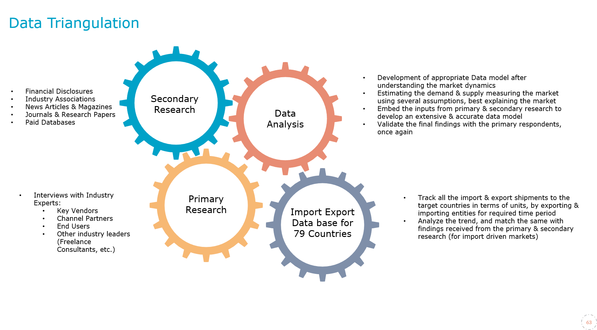
4. Data Forecast and FinalizationThe final phase involves forecasting future market trends based on the analyzed data. MarkNtel Advisors utilize predictive modeling and time series analysis to anticipate market behaviors. The insights are then compiled into comprehensive reports, featuring visual aids like charts and graphs, and include strategic recommendations to inform client decision-making
We offer flexible licensing options to cater to varying organizational needs. Choose the pricing pack that best suits your requirements:
Buy Now Inquire Before Buying
 Request Customization
 Talk to our Consultant